Thursday, May 28, 2009
Friday, May 22, 2009
Thursday, May 21, 2009
Site survey
We are going to tell you in 6 paragraphs why site 4 is so awesome. The people in site 4 are Ethan, Tyler, and Haylee.
First we will tell you about the riparian zone. The left bank looking down stream is 50-100’. Right bank looking down stream is over 100’. We had no conifer trees, we had sparse deciduous trees, and we had moderate shrubs, and abundant grasses and herbs. We had 25-50 over head canopies.
Second the shape of the stream bank was most like a square. The longitudinal pattern was meandering. The gradient was low.
Third the numbers of riffles are 7. The % of pools are 10. The numbers of pools are 2 but 90% of the stream is pools. There was abundant woody debris and abundant organic debris.
Fourth, we will tell you about the artificial structures at our site. In the stream reach there was wires around the trees to keep the beavers from chopping them down. Alongside of the stream reach there was a bridge.
Last, we will tell you about the land uses adjacent to reach. We had Residential development over our hill to our west. There is no other land use by people that we could see.
Tuesday, May 12, 2009
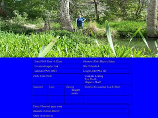
Our Photo Point 1
Location Douglas Creek
Date and Time 5/809 10:12
Observer Tyler,Haylee,Ethan
Latitude 47*29.315N Longitude 119* 54.113
Site Codesite 4
Location Descriptionsite 4
Purpose/Question How will the vegetation on the log change?
Notes
Map
Date5/8/09 Time10:12am
ObservercTyler,Haylee,Ethan
Locationdougals creek
Site Codesite 4
Latitude47*29.315N
Longitude119*54.113
Photo Point Code A
Compass Bearing
0True North
1Magnetic North
Camera4
Lens
Camera Height 1meter
Distance from meter board 15feet
Plants Observed grass trees
Animals Observed beaver
Other observations
Subscribe to:
Posts (Atom)


